
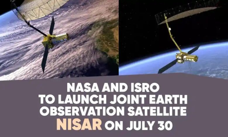
India Launches NISAR: ISRO-NASA Joint Earth Observing Satellite
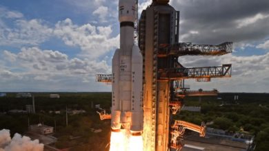
The National Aeronautics and Space Administration (NASA) and the Indian Space Research Organisation (ISRO) collaborated to develop the NASA-ISRO Synthetic Aperture Radar (NISAR), which was launched from GSLV-F16.
The goal of this first-of-its-kind collaborative effort is to gather fully polarimetric and interferometric data through a global microwave imaging mission in the L and S bands. NISAR is more than simply a satellite; it is a prime example of how the United States and India can work together to use space technology to solve global issues.
Comprehending NISAR
Built on ISRO’s I-3K framework, NISAR is an Earth observation satellite. It is equipped with Synthetic Aperture Radars (SAR) in the L and S bands. NISAR functions consistently day and night through clouds, smoke, and vegetation, unlike optical satellites that are constrained by weather and sunshine.
The dual-radar system on the satellite functions similarly to two different eyes scanning the Earth. The L-band radar functions similarly to an X-ray machine, penetrating soil and seeing through forest canopies to identify changes beneath the surface. This makes it appropriate for following the growth or shrinkage of forests, tracking the flow of ice within glaciers, and identifying changes in the ground that could indicate an impending earthquake.
Like a camera, the S-band radar concentrates on surface features. It is effective in measuring soil moisture content, tracking changes in snow cover, and keeping an eye on crop health. When combined, these two systems give us a comprehensive picture; the S-band displays surface conditions, while the L-band informs us of what is occurring beneath the surface.
Innovation and Technical Prowess
Additionally, the NISAR integrates a number of innovative technologies that raise the bar for Earth observation missions. It is one of the biggest deployable mesh antennas ever used for Earth observation, measuring a whopping 12 meters. This makes it possible to retain high resolution imaging over 240-kilometer swaths.
The satellite can cover large areas without sacrificing image quality thanks to the ground-breaking SweepSAR design, which is being used for the first time in orbit. More data than any other remote-sensing satellite, NISAR will generate almost 80 terabytes of data every day as it scans almost all of Earth’s land and ice surfaces every 12 days.
The technical intricacy of the mission necessitated unprecedented cross-continental collaboration amongst teams. The S-band radar system, data processing, downlink, spacecraft, and launch mechanism were all designed by ISRO. The GPS receiver, solid-state recorder, downlink, L-band radar system, and 9-meter boom with 12-meter reflector were all donated by NASA.
NASA supplies orbit manoeuvre and radar operations plans, while ISRO manages satellite command and operations. After being downloaded, the obtained photographs will be analysed and distributed to users by NASA and ISRO ground stations. Significant engineering collaboration and mutual confidence between the two agencies are demonstrated by the successful integration of independently designed components.
Applications of Transformative Science
The skills of NISAR span several crucial areas that have an immediate bearing on global issues:
Climate and Environmental Monitoring: Think of NISAR as the health monitor for the planet’s climate and environment. It keeps an eye on glaciers and ice sheets, monitoring the planet’s temperature through its frozen areas. NISAR helps scientists understand how sea levels can rise by detecting when glaciers melt more quickly than usual.
Risk assessment and disaster management: NISAR functions significantly more effectively than a sensitive seismograph in space. As little as a few millimetres of movement in the ground can be detected by it. Because of its sensitivity, it can detect landslides, earthquakes, and volcanic activity before they become dangerous.
Food and Agricultural Security: NISAR is like having a very powerful agricultural advisor in space for farmers. By sensing soil moisture levels over large areas, the satellite can provide farmers with precise information about how much water their crops require.
Ecosystem and Biodiversity Conservation: NISAR keeps tabs on Earth’s green wealth by monitoring wetlands and forests like an environmental accountant. It can determine if trees are increasing or losing biomass as well as how much carbon they are storing. Within days, NISAR can identify changes in forests caused by natural disasters or illicit logging.
Impact Worldwide and Open Data Policy
The collaboration between ISRO and NASA signifies a change in space diplomacy. This partnership expands on decades of collaboration, which included NASA’s Moon Mineralogy Mapper instrument on India’s Chandrayaan-1 lunar mission. NISAR, however, is the first time that these two space organisations have worked together to create an entire satellite system from inception to launch.
On July 30, 2025, NISAR launched aboard a GSLV-F16 launch vehicle from ISRO’s Satish Dhawan Space Centre (SDSC), also known as Sriharikota High Altitude Range (SHAR), which is situated in Sriharikota on the Indian peninsula’s southeast coast.
NISAR’s dedication to global scientific equity through open data access is among its most important features. Within one to two days of collecting, all mission data will be publicly accessible worldwide, with access in almost real-time during crises. Developing nations without their own satellite capabilities especially benefit from the democratisation of high-quality Earth observation data.
International climate research, disaster response, and environmental monitoring initiatives are supported by the mission’s open data policy, which turns knowledge acquired from space into a global public good. This strategy upholds the idea that cooperative scientific endeavours and shared access to vital information are necessary to address global issues.
Strategic Consequences for India
The NISAR satellite mission offers India several strategic advantages. It fortifies the strategic alliance between the US and India and establishes the nation as a world leader in cutting-edge Earth observation technology. The mission is in line with India’s national aims, which include catastrophe risk reduction, sustainable development objectives, and climate pledges made under the Paris Agreement.
India’s advanced space capabilities are demonstrated by ISRO’s significant contribution to the mission, which included everything from launching the spacecraft to providing the spacecraft bus and S-band radar. India’s position in the global space economy will be strengthened and future space missions will benefit from the collaboration’s creation of invaluable technical knowledge and experience.
Future Outlook and Long-Term Goals
Future multinational space partnerships can follow the model set by NISAR’s success. The mission’s novel co-development approach, in which the resources and competence of both agencies are equal. This may lead to similar collaborations tackling other worldwide issues.
The incorporation of machine learning and artificial intelligence into Earth system modelling is expected to be accelerated by the constant flow of high-resolution data from NISAR. More precise climate forecasts, better readiness for disasters, and better environmental management techniques are all anticipated as a result of this technical advancement.
In conclusion
The NISAR reflects a vision of global collaboration tackling common planetary issues, making it more than just a technical accomplishment. This Earth observation satellite will support global efforts in climate science, disaster relief, and sustainable development by offering previously unheard-of insights into Earth’s dynamic processes through the NASA-ISRO partnership.
The mission is poised to transform our knowledge of Earth’s dynamic systems. NISAR demonstrates how space exploration can benefit humanity as a whole while fostering strategic alliances between countries by fusing state-of-the-art technology with open data access and international cooperation.
The accomplishment of the mission will surely serve as motivation for future cooperative endeavours, proving that the most important global issues call for a pooling of knowledge, resources, and dedication to the common good.